
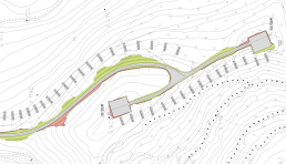
Alignment design
Windfarm infrastructure design is carried out using 3D models based on local site surveys. When a specific survey is not available, 3D digital maps can also be used as an alternative, even though the accuracy may be consistently reduced.
The existence of a three dimensional ground representation is fundamental for producing an estimation of the cut an fill volumes, as well for the definition of the necessary earth works whenever the terrain conditions become complex.
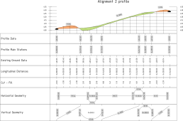
Profiles
Elevations are controlled taking into account of the earth movements, but also considering the logistic aspects of the windfarm. Wind turbine components transportation often require the adaptation of the bends and of the vertical curves to the dimensions of the components themselves and also to the geometry and kinematics of the vehicles.
Simulations
Windfarm infrastructure design and construction works requires often a transport simulation of the component in order to verify the site roads and the public roads. Furthermore, the construction of a windfarm in mountain areas may require major adaptation to public roads to allow moving tower sections and blades to the site.
We perform CAD simulation of new or existing infrastructure as part of due diligence or design processes. Based on the outcome of the simulations, we can plan the necessary adaptations (widenings, earthworks etc.) to predict and mitigate the impact of such modification on the final budget.